File:Marine shoreline of Cayo Costa Island (Gulf of Mexico coast of Florida, USA) (23771084953).jpg

Original file (3,939 × 2,891 pixels, file size: 3.55 MB, MIME type: image/jpeg)
Captions
Captions
Summary[edit]
_(23771084953).jpg&action=edit§ion=1)
| Description |
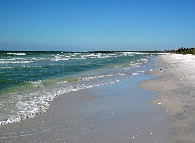
Marine beach at the southern end of the Gulf of Mexico margin of Cayo Costa Island, Florida, USA (looking ~north) (January 2016). Cayo Costa Island is one of dozens of barrier islands in the West-Central Florida Barrier Chain. This 191-mile long, slightly sinuous stretch of islands is located along the Gulf of Mexico coast of southern Florida. The southern-most island in the chain is Cape Romano Island. The northern-most islands are the Anclote Keys. Cayo Costa Island is located between North Captiva Island and Gasparilla Island, offshore from the towns of Fort Myers and Cape Coral, Florida. Most of Cayo Costa Island is a state park and is only accessible by boat. Cayo Costa is on the western side of Pine Island Sound, a large lagoon just south of Charlotte Harbor. Two large tidal inlets border Cayo Costa Island - Captiva Pass to the south and Boca Grande Pass to the north. Cayo Costa is a classic example of a drumstick barrier island - it is wide on its northern end and tapers to a point or hook on its southern end. This shape is the result of long-shore currents along the coastline. Other islands in the barrier chain also have this morphology. Cayo Costa Island and nearby North Captiva Island, Captiva Island, and Sanibel Island are Holocene barriers that rim the western and southern sides of a Late Miocene depression that is now Pine Island Sound. Middle Miocene limestone bedrock was subject to significant dissolution and karst/cave development. The Pine Island Sound area was a large karst depression in the Late Miocene. It is now filled with sediments - most of modern Pine Island Sound is significantly shallow. West-Central Florida Barrier Chain geologic info. synthesized from: Evans et al. (1985) - Bedrock controls on barrier island development: west-central Florida coast. Marine Geology 63: 263-283. Davis (1989) - Morphodynamics of the West-Central Florida barrier system: the delicate balance between wave- and tide-domination. Proceedings, Koninklijk Nederlands Geologisch Mijnbouwkundig Genootschap Symposium, 'Coastal Lowlands, Geology and Geotechnology', 1987: 225-235. Evans et al. (1989) - Quaternary stratigraphy of the Charlotte Harbor estuarine-lagoon system, southwest Florida: implications of the carbonate-siliciclastic transition. Marine Geology 88: 319-348. |
| Date | |
| Source | Marine shoreline of Cayo Costa Island (Gulf of Mexico coast of Florida, USA) |
| Author | James St. John |
Licensing[edit]
_(23771084953).jpg&action=edit§ion=2)
- You are free:
- to share – to copy, distribute and transmit the work
- to remix – to adapt the work
- Under the following conditions:
- attribution – You must give appropriate credit, provide a link to the license, and indicate if changes were made. You may do so in any reasonable manner, but not in any way that suggests the licensor endorses you or your use.
| This image was originally posted to Flickr by James St. John at https://flickr.com/photos/47445767@N05/23771084953. It was reviewed on 14 August 2016 by FlickreviewR and was confirmed to be licensed under the terms of the cc-by-2.0. |
File history
Click on a date/time to view the file as it appeared at that time.
| Date/Time | Thumbnail | Dimensions | User | Comment | |
|---|---|---|---|---|---|
| current | 17:25, 14 August 2016 | | 3,939 × 2,891 (3.55 MB) | Ser Amantio di Nicolao (talk | contribs) | Transferred from Flickr via Flickr2Commons |
You cannot overwrite this file.
File usage on Commons
There are no pages that use this file.
_(23771084953).jpg&oldid=700274909)